Tuesday, September 25, 2018

Yosemite, Part 2

Tuolumne Meadows
While there are many amazing places to visit in the Yosemite National Park, we were constrained by time and human weakness to choose only a few, and those that didn't require a long hike.

There are two waterfalls in the Yosemite Valley that Mark really wanted to get up close to:  Vernal Falls and Nevada Falls. Granted, they are more spectacular in the spring and early summer than they are at the end of a dry year. Nonetheless, Mark really wanted to make the hike. "It's a short hike," he said. So back to Yosemite Valley we went for our short hike to Vernal and Nevada Falls. It was a half mile walk from the parking lot to the trail head. Later we realized we could have taken a free shuttle, but hindsight is...well, more or less worthless most of the time. The sign said 0.8 miles to the Vernal Falls Bridge, which is at the bottom of Vernal Falls. "We can walk 8/10 of a mile," we said, and off we went. We were treated right away to the sight of a few deer in our path. Then came the up-up-up climb. "Take water," the sign said. "Who needs water for an 8/10 of a mile hike?...in 70 degree weather," we scoffed. And not much would persuade either one of us to walk a half mile back to the car to fetch our water. So on we went.

One of our many rests on the trail
Here's some more hindsight:  if I had known that we were, in essence, about to climb 8/10 of a mile of stairs, I would have found a nice seat in the shade and encouraged Mark to enjoy himself while I waited for his hopeful return. But, on we went. In no time at all, my heart rate monitor watch was registering above 110 beats per minute (my normal pulse is between 50 and 60), and there it stayed all the way to the top. We found ourselves sitting down on a stone to rest about every hundred feet or so toward the end, and more than once I considered asking total strangers for a sip of their water. Finally, after about an hour, we came to the bridge, which is a little over half way to the top of Vernal Falls. Nevada Falls is a further two or three miles...up.

Can you see the waterfall???
Needless to say, the Bridge is as far as we got. We could see the tiny little water fall away in the distance. But, hey, we got in a good cardio walk, so it wasn't a total waste, right? And there was a water fountain.

The sad truth is, most of the beauty of Yosemite is available only to the hiker who is willing to walk and camp for days in the wilderness. I, for one, am thankful for the roads and the automobiles that make it possible for old, out-of-shape city folk (and the disabled) to see at least some of the splendors of places like Yosemite.

Our next day trip was to Tuolomne Meadows (pronounced "too-all-o-mee"). The road to Tuolomne is a slow climb that reaches over 8,000 feet at the Meadow. Along the way is a spot called Olmstead Point. Here you can see giant slabs of granite and boulders scattered across the landscape. Pictures capture only part of what the eye sees and cannot do it justice. I couldn't help wondering how such a place came to be. We continued driving over Tioga Pass, which is a hair short of 10,000 feet, to Tioga Lake, just outside the eastern Park entrance, and then headed back to Tuolomne Meadows for lunch before returning home.
Olmstead Point

We saved Mariposa Grove for last, reasoning that if something happened to cut short our stay, we could see the Sequoias when we get to Hanford, our next stop, if we missed them at Yosemite. But we didn't.

The Mariposa Grove of redwood trees is at the very southern tip of the Park. It was another very long drive. Mark and I managed all our long day-trips by drive-sharing. He drove to and I drove home. This gave us both an equal opportunity for sight-seeing. Some years ago, the Park closed off the Mariposa Grove to individual vehicles and implemented a free shuttle service into the area. So we parked the car and boarded the Sardine Shuttle to see the trees. It's a good thing I wore my hiking shoes, because the only way to see these trees now is by a hiking trail that steers you through the woods in a loop approximately a mile and a half. There was a good uphill climb on this one too, but not nearly as strenuous as the Vernal Falls adventure. We concluded that we probably need to do more hiking to get in shape...and stay in shape...but we probably won't.
The "Sardine Shuttle"

We added Yosemite to our travel plan at the last minute; originally we'd planned to come here next year. It has turned out to be one of our best stops so far in our entire year of travels. We'll likely come back again, but next time it will be in the spring or early summer, when the waterfalls are flowing.


More Pictures...

View from Vernal Falls trail

Deer in the Park
Another view from Vernal Falls trail

Going down was easier the climbing up
The high meadows
Tenaya Lake between Olmstead Point and Tuolomne
Another view of Olmstead
"Management Fire" on the way to Tuolumne
The back side of Half Dome, seen from Olmstead Point
Tioga Lake, outside the Park east entrance
Mariposa Grove

Grizzly Giant

Redwood roots

The "Tunnel Tree"

Monday, September 17, 2018

Awesome Yosemite Valley


Lower Yosemite Valley (Half Dome in the distance)
Mark has been to Yosemite before, but this is my first time. Making this a two week stay was a very good decision because it's impossible to see very much of the park in just a few days.

We have decided on several day trips with the car while we're here. Our first trip was to Yosemite Valley, where the famous El Capitan and Half Dome rock faces can be seen. There is an interesting Welcome Center here where you can read all the fairy tales about how Yosemite valley was formed a gazillion years ago, when of course everything was meticulously recorded for posterity. I'm going with the Genesis account, which God himself provided to us, because He was actually there (Job 38). Looking at the topographical map of the area, it's easy to imagine the mountains being split apart in a great upheaval (the Great Flood, perhaps?) If it were possible to fold the mountains back up again, you can almost see Half Dome fitting up neatly against the rock face on the opposite side of the valley. But I digress.
The topographical map

There is also a nice general store with everything from memorabilia to groceries to double chocolate Haagen-dazs bars. I bought one of those (of course) and a jar of local blackberry jam. I've had to curtail my habit of purchasing a coffee mug commemorating the places we visit, mainly because I no longer have any space to store them. So instead, we buy things we can eat. And sometimes clothes. But mostly food.

Hetch Hetchy Reservoir
Our next day trip was to Hetch Hetchy (catchy, isn't it?) Reservoir. The scenery was amazing. I found myself singing that old chorus, "Our God is an Awesome God," for the rest of the day. Hetch Hetchy Road is sometimes shared with grazing cows, some of whom challenged our right to be there. But in the end, they decided they didn't want any trouble, and moved off to the side.

If only you could see their eyes...
daring me to take the road.
I did.
They moved.
Yes, that's smoke rising in the middle
And Saturday we made the very long and treacherous drive up the mountain to Glacier Point, which is more or less opposite of Half Dome. Had we thought more carefully about our timing, we would have waited until the not-weekend, as the area was packed with tourists. (Those darned tourists!) We crept along in a car queue for about half an hour just to get into the parking lot. Nevertheless it was worth the effort. This is one of the areas of the most recent fires in Yosemite. Parts of the forest are still smoldering, It was a little disconcerting, partly because of the smoldering trees, and partly because of the bareness of the hillside, which makes visible the height at which we were driving along on that narrow winding road.

The viewing area is the home of that infamous jutting rock that hangs out over the cliffs, upon which many people have stood to have their pictures taken, and from which many have fallen to their death because they were idiots. On that day, idiots abounded, sitting and standing on precipices for a picture. Fortunately, none (to my knowledge) lost their lives.
Glacier Point

Yosemite Valley and Hetch Hetchy were the shortest of our scheduled day trips. The Glacier Point. drive took us six hours round trip. We'll also be going to Tuolumne Meadows and the Mariposa Grove (giant redwoods), which are at opposite ends of the Park. Each of those drives is expected to take roughly about the same time.

The weather has been lovely so far. It got a bit hot the first two or three days, but since then it's been in the low 80's and breezy, and as soon as the sun goes down, it cools down right away.

Mark has solved one of our periodic power problems:  the one where we can only get 30 amp campground sites. When we're in those low-amp sites, we can't use our basement air/heat and we have to run the fridge on propane to keep it at the proper temperature.

Typically, sites that have 30 amp plugs also have a plug for 15 or 20 amps on the power post. We've purchased a pigtail adapter that allows us to plug into two outlets-- two 30 amp outlets, if available, or a 30 and a 20, providing us plenty of power to run everything in our coach without tripping circuit breakers. In this park, we're borrowing the 30 amp outlet from the site next to us since its empty.  It was a cheap fix that will open up our options moving forward.

That's it for now. Enjoy the pictures!


Hetch Hetchy Reservoir

View from the tunnel on the other side of the dam
El Capitan

Hetch Hetchy

Half Dome

View from Glacier Point

Bridalveil Falls

Bridalveil & me
Flowers

.

Tuesday, September 11, 2018

Journey's Mercies

Yosemite Lakes campground
We were reminded again this past week of how God's providential hand works in our lives. Here's the story...

We had originally planned to take Highway 101 straight south from Whaler's Rest, in South Beach, Oregon, to Crescent City, California. Our GPS told us we should instead go over to I-5 and then south to Grants Pass and back to the coast on US 199. So we headed east on US 20 for Albany and the freeway. Had we not followed that "urging," we might have been in real trouble.

About halfway to Albany, the coach started to give us trouble on the hills, reminiscent of our "adventure" last year heading out from Minnesota. Before long we were struggling along at 25 or 30 mph on every climb and sometimes slower than that. We knew we were going to need some maintenance, so I pulled out my phone and started googling diesel engine repair businesses, specifically CAT engine shops. We found one right off the highway near Corvallis. By the time we neared town, our top speed was down to about 40 mph on the flat road. We didn't bother to call first, and it turned out that they only dealt with agricultural equipment. They referred us to another repair shop not far down the road, but that place told us their schedule was packed out and there was no way they could get us in. . However, they were kind enough to refer us to a place in Albany that could help us-- McKay's Truck & RV Repair. This time we called first. They said, "Come on over, we'll fit you in."
At McKay's for repairs

McKay's had us fixed and running like a charm within a few hours. They replaced our fuel filters, and in the process found a crimped and very damaged fuel line which they also repaired. (Maybe our fuel mileage will improve...we can hope.) While they were at it, we asked them to replace our chassis batteries. Mark has been having trouble starting up the engine over the past month or so, and we were planning to replace them soon anyway.

I have visions of what might have been, had we followed our original plan:  The Follymobile, stopped in the middle of the winding two-lane, sometimes mountainous road that is US 101...on a hill...blocking traffic for a mile behind us, with no repair shops within a hundred miles... waiting for a tow truck.

Our Heavenly Father has been so faithful to us. We don't deserve it by any stretch, yet He comes through for us in the most unexpected ways over and over again.

The Crescent City campground reservation was for only two days, and since it was out of the way at this point, we ended up cancelling it altogether. With no campgrounds reserved until Yosemite, we decided to just go directly there and adjust our reservation as needed.

Our detour
The California wildfires are still going strong in many places. Before we left Oregon, we checked the California Fire Map and found a big red blob right over I-5 between Mt. Shasta and Redding, smack dab in the middle of our path. That particular fire started only the day before we left, but by Thursday that section of freeway was closed in both directions and we were forced to take an eighty mile detour. Pray for rain. The fire fighters are maxed out. We passed a half dozen or so firetrucks and vehicles with their sirens blaring as we headed east toward Yosemite on the last leg of our journey. I read recently that "fire season" generally starts after Labor Day (Who knew there was a "fire season?"), and California has already burned through most of their fire-fighting budget (pardon the pun). Again, pray for rain.
One of several fire crews heading out


So here we are in Yosemite. Getting to the campground was hair-raising. More of those winding, two lane mountain roads. It was a hard climb for our poor old Follymobile, but we got to the top with no other problems. The campground is very remote. We're about five miles from the Park entrance and roughly 18 miles east of Groveland, the nearest real town. We have no phone service here and very poor internet, though there are locations not too far away that we can drive to periodically to check e-mail, make phone calls, and use our data hotspot to take care of our internet activities...such as posting to this blog.
Forgive the window glare...this was looking back as we
climbed Hwy 120 to our campground.


Otherwise, we're communing with nature, and praying that we don't get caught in the middle of any fires or earthquakes while we're here. I'm not too worried. After all, we have a Heavenly Father looking out for us. Even when things look as though they are going wrong, ultimately His good purpose is revealed and His faithfulness to us is confirmed once more.

Matthew 7:11


Thursday, September 6, 2018

A Short Break From Summer

Seaside "Turnaround"
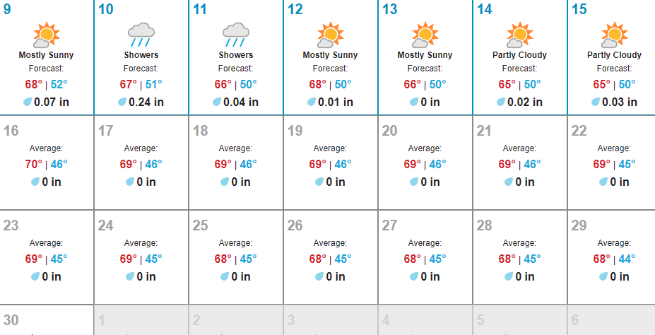
We imagined that the coast of Washington and Oregon would be warm and pleasant in August. Not so. It pays to check weather statistics rather than one's imagination. The Wunderground (Weather Underground) internet site shows average temperatures in August for our chosen location to be in the upper sixties. And so it has been. It left us wondering what happened to summer. But the break from the heat was okay. We'll be back into it again soon enough. On the positive side, we also got a break from the choking smoke, for a while at least.

For whatever cosmic reason, campgrounds are rarely situated in prime locations...and we've yet to find one right next to the beach, though I'm told they do exist. The campground in Seaside was about a mile inland from the beach-- close enough to ride a bike to, but we didn't. We were lazy and drove the car.

The town of Seaside has a beautiful beach, long and wide, and all of it with public access. Unlike some parts of the country, there is no private beach ownership in Oregon. You can own property up to, but not including the beach. That makes it really nice for "Joe Public." The downtown area is charming-- full of shops and restaurants. It has a beach-side promenade that runs a mile or two on either side of the "turnaround" at city center, and we walked a good portion of it on one of our visits.

We were only in Seaside for a week this time, but we liked it enough that that we've decided to make it a two or three week stay the next time our path takes us along the coast of Oregon.

The Column in Astoria
While we were there, we drove up to Astoria, Oregon, which is across the Columbia River from Washington, about ten or fifteen miles north of us. Astoria was fun to visit as well. They have a viewing tower on a hill, called "The Column," that we climbed for an amazing view of the surrounding area. We also visited their Maritime Museum. They have several other small museums that we didn't have time to check out, but we'll catch them on our next time through. And then there was the trolly. It costs a dollar to ride it (two dollars for an all day pass) and it will take you from one end of town to the other, with stops all along the way. And you get a brief narration of some of the history of the town in the bargain.

Between the provencial towns of Seaside and Astoria is Warrenton. It seems to have differentiated itself as the modern business center of Oregon's north coast. I imagine them saying, "Whatever store you don't want defiling your picturesque environment, we'll build it here." Warrenton is where you will find Costco, Walmart, PetCo, Staples, Home Depot, and pretty much any other modern shopping establishment you may need. I even found a Natural Grocer store. That was a pleasant surprise. We made a one-day shopping spree into Warrenton to get our main groceries for the month and pick up cat food and other supplies.

Since we no longer needed to stop in Pacific City (having experienced the miraculous healing of our electrical problem), Mark checked almost daily to see if we could extend our existing bookings to absorb those two days. There was no point in making another stop, and we didn't really like Pacific City the first time we were there. Both parks were booked solid. Every time he called, the answer was: "Sorry, it's completely full." But persistence sometimes pays off. You never know when someone will cancel or leave early. Fortune smiled on us and we were finally able to get an extra day at both Whaler's Rest and Seaside.

Dinner with a view
Whaler's Rest is a few miles south of Newport, Oregon, in a place called South Beach (I'm not sure it's even a town). We arrived on Mark's birthday. After getting all settled into our spot, we drove into Newport and had dinner at a lovely restaurant called Georgie's Beachside Grill. It was very good food, but Mark was disappointed that they didn't have lobster, the one thing he'd made up his mind that we wanted for dinner. But, he got his ribeye steak & fixin's and I promised him a rain check on the lobster.

There is actually whale watching in this part of Oregon. I'm sure I saw a breaching whale from the RV as we were driving by Depoe Bay, a town a little north of Newport. There was a whale-watching boat nearby my sighting and it circled around, so apparently they saw it too. Taking one of those whale-watching tours is on my bucket list. Someday!

Lovely pool - no hot tub :-(
Whaler's Rest is a nice enough park. They have plenty of 50 amp full hookups, but the phone reception (Verizon) was weak and the only place we could get internet was the clubhouse. The indoor swimming pool is fairly large and the water is warm, but the hot tub was closed for service both days we wanted to use it. No place is perfect, I suppose.

The "tunnel" at the aquarium
On our last day there we drove up to Newport and visited the Oregon Coast Aquarium. It's rated one of America's top ten aquariums. It has some nice features. The walk-through tunnel filled with fish, manta rays and sharks was pretty cool. Outside they had habitats for seals, sea lions, and sea otters, which are always fun to watch. And in the aviary, they had puffins and other sea birds. It was worth seeing for sure. Afterward, we took our beach chairs and jackets and sat out on the beach for an hour or so. In the sun it didn't seem like 60 degrees. The water, however, was frigid.
Enjoying the sun at the beach


Highway 101 is a beautiful scenic drive... in a car. I don't much like taking the RV down it. Our GPS agreed, and we have decided to take its advice and pop over to I-5 on our way out and skip Crescent City this time.

California, here we come!

Naptime?